Background on Map Projections
In order to create a map of a spherical object such as the Earth it is first necessary to convert the Earth coordinates of latitude and longitude into a two-dimensional coordinate system needed for a map. This conversion from the spherical coordinates of latitude and longitude to some xy Cartesian coordinate system is called a map projection. Mapmakers and mathematicians throughout history have invented many map projections. For each map, the mapmaker must decide which projection will look best for his or her purposes. This will depend on what part of the globe is being drawn, the size of the area being drawn, and the shape of the object being drawn. In general, map projections fall into three standard classes: cylindrical, conical, and planar. For a complete analysis of the topic of map projections see reference 1.
For maps of North America, PowerWorld supports a Simple Conic map projection which is described below.
For maps of the entire Earth, PowerWorld supports a Mercator projection which is described below.
Simple Equidistant Conic Map Projection
For maps made of the 48 conterminous states in the United States, maps are often made using one of the conical map projections. These projections can be recognized by the constant latitude lines that are seen as arcs. When looking at the U.S./Canadian border in the western United States, you will see that it curves on maps made using a conical projection, even though this is a constant latitude border. Several conical projections exist including the Albers Equal-Area Projection, Lambert Conformal Projection, and Simple Equidistant Projection. They can be visualized as taking the globe and placing a cone over it as shown in Figure 1 and then using this to map the coordinates to the xy plane shown at the right. Constant longitude lines are seen as straight lines and constant latitude lines are seen as arcs on the resulting map.

The equations for converting back and forth between (longitude,latitude) and (x,y) using the simple equidistant projection are described next. These equations are taken from reference 1.
First, you must specify seven values that are parameters of the mapping:

For these values, the following variables are defined:

Then given a latitude = ϕ and a longitude = λ, calculate the x and y coordinate using

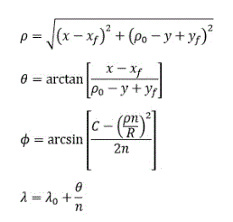
And given an x and y coordinate, calculate the latitude(ϕ) and longitude(λ) using

Figure 2 shows more clearly what some of these variables are.

Albers Conic Equations:
The equations for converting back and forth between (longitude,latitude) and (x,y) using the simple equidistant projection are described next. These equations are taken from reference 1.
First, you must specify seven values that are parameters of the mapping:
For these values, the following variables are defined:

Then given a latitude = ϕ and a longitude = λ, calculate the x and y coordinate using

And given an x and y coordinate, calculate the latitude(ϕ) and longitude(λ) using
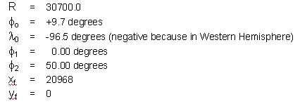
Maps made using PowerWorld's built-in map borders for North America use the following parameters:
These numbers were thus set to be the default map projection numbers within PowerWorld. This projection will work well for the one-line diagrams with PowerWorld Corporation has created on the same standard background.
Mercator Projection Use in PowerWorld
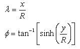
For the Mercator Projection, PowerWorld assumes R = 30700.0 units. From this, given a latitude = ϕ and a longitude = λ, calculate the x and y coordinate using

And given an x and y coordinate, we calculate the latitude(ϕ) and longitude(λ) using
References
- Snyder, John P., Map Projections - A Working Manual, U. Geological Survey Professional Paper 1395, United States Government Printing Office, Washington, D.C.: 1987.